

Mesoscale Modeling
Introduction
The towers in the INL Mesonet
[link] provide
comprehensive information about the current state of the weather in
the Snake River Plain, but they do have some limitations. First, most
of the towers are 15 m tall, so they mainly provide a picture of
near-surface conditions. Given the nearby mountainous terrain, the
conditions at even a small height aloft can be quite different from
those observed by the towers. A second limitation of the towers is
that they show the current state of the weather, but do not forecast
what conditions will be in the future. Many of ARLFRD's partnership
activities with INL (e.g., dispersion modeling and wildfire support)
involve forecasting winds and weather several hours into the future
rather than just providing current conditions.
One approach to overcome some of these data limitations is to run a
mesoscale weather prediction model over the region of interest. Such
models provide a three-dimensional representation of the atmosphere
and are similar to the numerical models run by NOAA to provide
national weather forecasts. ARLFRD currently runs the WRF ARW
mesoscale model [link]
as part of its collaboration with INL.
|
 |
ARLFRD runs the WRF mesoscale model to
make high-resolution 6-12 hour
forecasts in the vicinity of INL.
|
WRF Configuration
ARLFRD runs WRF with two grids as shown in the figure. The outer grid
spans most of southern Idaho and parts of the surrounding states; it
uses a 20 km horizontal grid spacing. The nested grid uses a
horizontal spacing of 4 km. Additional configuration details are given
below:
- ARW model version 2.2 (soon to be upgraded to 3.2).
- 33 vertical levels.
- Two-way nesting.
- Initialized from 20 km RUC model output.
- RUC land-surface model.
- Mellor-Yamada-Janjic PBL scheme.
- Ferrier microphysics scheme.
- Kain-Fritsch cumulus scheme on coarse grid.
- Model runs every three hours
Output from the daily model runs are available here
| |
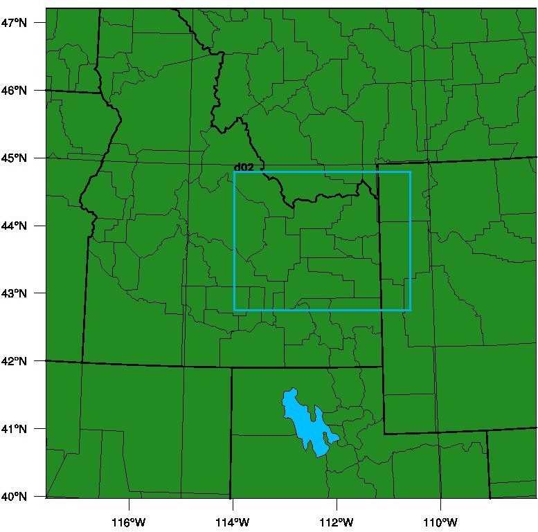
Map showing the two WRF grids. The
innermost grid covers the INL and surrounding
towns and cities.
|
Linkage to HYSPLIT
Another advantage of the mesoscale modeling is that the WRF output is
easily ingested into the ARL HYSPLIT dispersion model
[link]. This provides ARLFRD with the capability of
making INL dispersion forecasts that account for the full
three-dimensional structure of the winds. In contrast, the current
modeling based on MDIFF [link] is
limited to a two-dimensional wind field based on the Mesonet data.
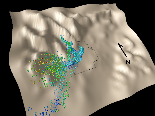 The figure shows one example of HYSPLIT output based on mesoscale
modeling for INL. HYSPLIT was run in full particle mode, and the
release point was set near TAN at the northern end of INL. The
particle colors are based on their height above ground level, with
blue particles being closest to the ground and red particles being the
highest aloft.
The figure shows one example of HYSPLIT output based on mesoscale
modeling for INL. HYSPLIT was run in full particle mode, and the
release point was set near TAN at the northern end of INL. The
particle colors are based on their height above ground level, with
blue particles being closest to the ground and red particles being the
highest aloft.
As can be seen, pollutant dispersion at INL can potentially be highly
complex due to interactions with the nearby terrain. Many particles
have been drawn up the Little Lost River Valley, and others have
collected at the mouth of the Big Lost River Valley near
Arco. Vertical motions associated with the mountains have lifted many
of the particles near Arco to higher altitudes. A fraction of the
original plume has remained in the Snake River Plain and continued
moving off to the southwest.
|